

How to Read a Topographic Map: Contour Lines, Scale, and North

How to Read a Topographic Map: Contour Lines, Scale, and North
FIELD MAP GUIDE
A topographic map is easier to read when you start with its margin. Check the contour interval and scale first, then use line spacing and map symbols to picture the ground.
Topographic maps put a three-dimensional landscape on a flat page. Their contour lines show elevation and the shape of the land, while other symbols mark roads, water, buildings, boundaries, and more. A quick read starts with the map’s own key and margin—not with assumptions that every sheet uses the same scale or interval.
Start with the contour interval
A contour line connects points at the same elevation. On a USGS topographic map, contours usually refer to elevation above a reference surface such as mean sea level. The vertical difference between neighboring contours is the contour interval. Find that value in the map margin before adding or estimating elevations; it can differ from one map to another.
Some maps emphasize an index contour with a thicker brown line and print its elevation. USGS specifications describe index contours as every fifth contour in that map design, but use the labels and interval printed on the sheet rather than counting by habit. Contours represent a simplified surface: they do not show every small bump or change in the ground.
Use spacing to compare slopes
With the interval in hand, compare the spacing between lines. Closely packed contours indicate a steeper slope; lines farther apart indicate gentler ground. This is a relative reading: line spacing only makes sense together with the map’s contour interval and scale. A tight cluster on one map cannot be compared directly with a different map that uses another interval.
Follow the pattern as a whole. A contour’s bends help show ridges, hollows, and valleys, while rivers, streams, and shaded relief provide additional clues. The map’s colors and symbols have specific meanings, so check its symbol guide instead of guessing from color alone. Contour lines on the same map do not cross because a single point on the ground cannot have two elevations at once.
Turn scale into distance
Scale is a ratio: 1:24,000 means one unit on the map represents 24,000 of the same units on the ground. For the standard USGS 7.5-minute series covering the contiguous United States and Hawaii, that works out to one inch for 2,000 feet. Alaska and other USGS products can use different scales, so read the sheet you have.
A scale bar is handy when measuring a printed copy, but printing or resizing can change the relationship between the paper and the original map. Check the bar on the copy in front of you. In a digital geospatial PDF, use the document’s measurement tools or coordinates; ordinary screen zoom is not a fixed map scale.
Check north and the map date
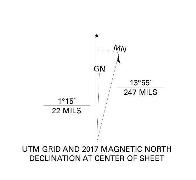
A USGS map may show true north, grid north, and magnetic north in a diagram near the margin. They describe different reference directions. The diagram also shows their angular differences for that map. If you are matching a compass to a paper map, identify which north reference you are using and consult current magnetic-declination information; do not treat all three arrows as interchangeable.
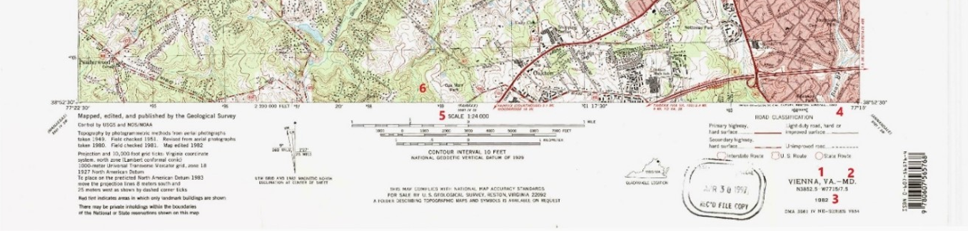
The margin also identifies the quadrangle, edition or imprint dates, and scale. Current US Topo maps and older historical sheets can show different information because maps are products of their dates and source data. If a route depends on a road, trail, boundary, or other feature being present today, check a current source as well.
A quick reading sequence
- Read the map name, date, scale, and contour interval in the margin.
- Find a labeled index contour and use the printed interval to interpret neighboring lines.
- Compare line spacing to distinguish steeper from gentler ground.
- Check the legend, north-arrow diagram, and scale bar before measuring or orienting the map.
- Confirm time-sensitive features with current information.
The map becomes much easier to use once its conventions are clear. The margin supplies the rules; the contour pattern and symbols let you apply them to the landscape.